Politics & Government
Middletown "Carefully Watching" Hurricane Earl's Path, Encourages Preparedness
Find out how Middletown officials are preparing for the storm and what steps residents can take right now to immediately prepare for hurricane season and natural disasters.

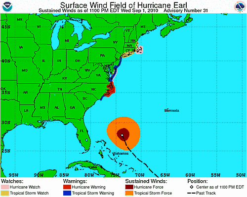


With local Emergency Management planners carefully watching, the National Weather Service (NWS) on Wednesday continued to track Hurricane Earl as a Category 4 hurricane with deadly winds of about 135 miles per hour cruising off the coast of Bermuda.
As of 5pm Wednesday, the storm was projected to barrel along the mid-Atlantic states before weakening to a tropical storm when it finally reaches Southern New England coastal communities late Friday night.
"Right now, we're watching it carefully and prepared to take any precautions as necessary. The way the storm is heading right now, we don't expect a very significant event like a hurricane, but in case it ends up moving closer inland, we're keeping a close eye on it," said Middletown's Director of Emergency Management and Fire Department Chief Ronald Doire. "Right now, unless it turns further inland, what we are expecting is 4-6 inches of rain over a 24-hour period to peak around midnight Friday, so we can expect some street flooding and high surf."
Find out what's happening in Middletownwith free, real-time updates from Patch.
Local surfers rely on magicseaweed.com as a reliable daily weather and marine report. On Wednesday, the website forecast called for 14-foot waves by 6pm Friday evening with 20 mph winds, then tapering off to 7.5-foot waves and 15 mph winds by 6am Saturday.
NWS projections on Wednesday also showed that Rhode Island is more likely to experience tropical storm force winds rather than hurricane winds, with the brunt of the storm to hit around midnight Friday about 75-100 miles outside Cape Cod and Nantucket Island.
Find out what's happening in Middletownwith free, real-time updates from Patch.
NWS meteorologist Kevin Cadima told WRNI Wednesday morning that the possibility remains the hardest hit areas out on Cape Cod and its smaller islands could face hurricane force winds.
"A track south of Nantucket would keep the worst of the hurricane force winds out over the ocean but this is a fairly expansive storm," Cadima says. "Even with a track south of Nantucket it would likely bring at least tropical storm force condition across parts of the South Coast, especially Cape Cod and the Islands."
Cadima said residents should closely watch the course of the hurricane, especially as it makes its turn off of North Carolina. A more eastern track would mean less of an impact in Rhode Island. A more western track could be much more substantial.
Right now, local Emergency Management officials are most concerned that Earl may move further inland west, potentially causing heavy flooding, wind damage, and a dangerous and destructive storm surge along Middletown's coastline.
On Wednesday, Doire was busy coordinating the local response, managing the flow of information and preparedness measures between the Rhode Island Department of Emergency Management, the lead disaster preparedness agency, and town departments, including the Town Administrator, Police Department, Public Works, Parks and Recreation, and Building Inspector.
Doire said state and local officials have another conference call scheduled early Thursday afternoon and that any beach closures or necessary precautions would be determined at that point.
"Our biggest concern are the beaches and low-lying areas," said Doire.
If Earl moves inland, Middletown's immediate concern would be for the summer residents at the town's Second Beach campground on Sachuest Point, said Doire. "They're the first ones at risk."
If evacuation is needed, the Gaudet Middle School would serve as the town's primary emergency shelter, followed by the High School as the secondary shelter.
If necessary, the town's Public Works Department would likely need to remove from the beaches some lifeguard stands, portable vaulted toilets, various storage containers, and other beach equipment to higher ground. If necessary, the town's Harbor Master would also assist boat-owners at the Third Beach Mooring area with securing or removing their boats, said Doire.
Regardless of how this storm pans out, Doire encouraged local residents to stay informed and prepare for hurricane season sooner rather than later.
Middletown's Director of Emergency Management and Fire Department Chief Ronald Doire recommends that Middletown residents:
- Immediately get familiar with Rhode Island's Emergency management website to stay on top of the latest updates and information, evacuation routes, and to follow recommendations for emergency preparedness;
- Visit the Rhode Island Chapter of the American Red Cross website for guidance on preparing for natural disasters and gathering emergency supplies;
- Sign up for Middletown's CODE RED emergency messaging system, managed by the Police Department, which generates automated recorded phone calls to residents containing valuable emergency information, evacuation instructions, natural disaster updates, and more.
"We can produce a recorded message to give information to any one particular area in town, or the whole town," said Doire, noting that CODE RED was most recently used during the spring floods and for missing person alerts several months ago.
Natural Disasters: Be PreparedThe Rhode Island Chapter of the American Red Cross cautioned people against waiting to the last minute to prepare for any natural disaster and encourages all households to take the following three steps:
According to the RI Chapter of the American Red Cross, a recent national survey revealed that only seven percent of Americans have taken the recommended actions to prepare for disasters and Red Cross officials urged the remaining 93-percent to prepare for the unexpected.
Get more local news delivered straight to your inbox. Sign up for free Patch newsletters and alerts.


